Saturday, October 29, 2011

second set of data collection


For our final map, we have decided to take 18 stitches inland across both coastlines which defines Auckland.

Along the Waitemata Harbour and Hauraki Gulf, we have chosen properties along and around
these streets:

1. Brighton Tce – Beach Road – Sunrise Ave – Eastcoast Road – Rose Dale Rd
2. Hinemoa Street – Rugby Road – Le Roy Tce – Birkenhead Ave – Glenfield Road
3. Attwood Road – Chatham Ave – Ridge Road – Wake Road
4. Pt Chevalier Road
5. Garnet Road - Old Mill Road - Surrey Cres
6. Hamilton Road
7. Orakei Road

8. Tamaki Drive - Kohimarama Road
9. Waitara Road - Riddle Road - Maskell Street
10. West Tamaki Road
11. Point England Road - Swainston Road
12. Hattaway Avenue - Bucklands Beach Road

Along the Manukau Harbour, we have chosen properties along and around these streets:

13. South Titirangi Road - Titirangi Road
14. Blockhouse Bay Road
15. Cape Horn Road - Dominion Road Extension
16. Frederick Street - Carlton Street - Hillsborough Road
17. Shortt Ave
18. Brundi Ave

Type of data:

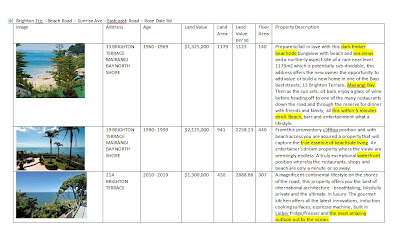
1. The picture is an important indicator of the value placed on water. Instead of taking the first picture, we have decided to look for one that has the most focus on water for each set.
2. The address
3. The age of the property
4. The land value
5. The land area
6. Calculate the land value/square meter
7. Building Area
8. Sometime we have missed in our previous attempt was the property description. We thought it is important to see how much is mentioned regarding water as well as how it mentioned ie. if it is just a mention that the property has views, or elaborate description of the views or an appeal to accessibility to the beach itself via a walk or drive.

Sample of one set of data (Brighton Tce – Beach Road – Sunrise Ave – Eastcoast Road – Rose Dale Rd)


Monday, October 24, 2011

redirection


Since my previous post, big changes and developments have occurred in this project. In our critique of the theme of our project, we have decided to change course drastically.

Our focus has shifted from investigating the memories and stories regarding various bodies of water in Auckland to investigating how Auckland is defined and ma
rketed in relation to residential properties which are in close proximity to the water. This is mainly due to the logistics of data collection and the interpretation of that data. In order t

o
collect the quantity and diversity of data sets that would be ideal, we would need ethics approval which can become a long and arduous route that we did not initially anticipate. Even with the data collected, there is difficulty in translating the written, drawn or oral information and representing it in a diagrammatic format.


The interest of how Auckland's residential houses has been marketed was due to discussions around the term 'value'. We have decided to investigate the marke

t value of Auckland's residential housing in relation to water. Our source of information is from a
real estate engine which is able to supply specific details for properties recently sold, is for rent or in the market for purchase within the last two years.

Auckland's identity in terms of waterfront properties.


- value of house

-value of land

-address

-distance from the water

Initial data collection:


In our first trial, we went around Herne Bay collecting data on properties closest to the coast line that has been advertised in the past two years. The columns were:
- first picture advertised
- address
- land value
- land area
- building area

Trial one:


Our first attempt at visualising the data we have collected. Each building's footprint is marked with a set of icons in close proximation which explains the its unique makeup. There were several flaws with this.

1. By collecting the data along the coast, it does not really show how water influences the land. Therefore, we have decided to collect data inland from the coast for the next map.

2. The way of showing data is very 'bitsy', as each icon signifies a piece of information, it takes a while for the reader to de-code this map.

3. Some of the techniques were visually misleading. The over lapping orange boxes which reads as a factor which influences one another, whereas in reality, it indicates localised land values specific to each property. The lines extending from the building reads as sight lines whereas it indicates value.